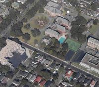
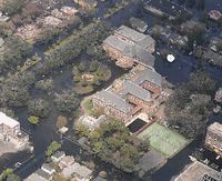
I supposed that the complex was not under water as it was built on higher grounds. So I started to look at Google Earth and later found maps indicating the breaches in the levies (the Dutch would say dikes). But it was hard to get an exact impression of what was going on in the neighbourhood. But last night I found perfect areal shots of the place. I saw that the buildings have not been hit hard; even the tenniscourts were dry. I found the photographs on the Katrina Flyover of MSNBC. The application they have is a combination between a map and a special photographs. It is a fine piece of journalism.


Notre Dame Seminary: before Katrina (left); after the hurricane (right)
A year ago this type of information would have been hard to come by. But since Google Earth maps are a hot item, which leads to creative application. I saw recently, for example, a map of the world on which the places of news items were dotted. Business wise this is also an interesting application to show company activities, clients activities (from where do they call), for e-mailers to see the their span of the world.

It is clear that we are adding a spatial dimension to government and business information. And from what I read there is more to come. I recently started reading Spatial Portals: Gateways to Geographic Information by Winnie Tang and Jan Selwood. I know Winnie Tang for almost a year now. I met her in Hong Kong last year May during the First Global ICT Summit. She is the founder and CEO of ESRI, a company specialising in Geographical Information Systems (GIS).
“Spatial portals are Web sites that make it easier to find, access, and use geographic information available on the World Wide Web. They are changing the way we interacxt with spatial information and have the potential to become the fundamental platform through which we discover, publish and share geographical knowledge.”
In the meantime various Geospatial One-Stop Portals are put on the map. These portals are interesting resources not only fore the use of the government, but also for citizens. In the book chapters have dedicated to GeoNorge, a national map portal for Norway; Transport Direct: Keeping Britain on the move; Mapster: Managing the waters of the Canadian Pacific; Scan: Public health information in South Carolina. Other chapters deal with the applications in institutes and companies: 12M portal: Managing US Navy Atlantic Fleet installations; GeoInfo One-Stop: Hong Kong’s planning information portal; Shell’s global portals: Connecting a global enterprise.
I guess because GI systems and software is still expensive applications for the private use by consumers. I would not mind having a system that tells me daily where my e-mails come from. Another application in the field of hobbyists would be the geographical distribution in genealogy. And what about a historical overview of the place, where you live now.
Spatial Portal gives an interesting outlook in the evolving developments in geographic information. It will not only make information more accessible but also more easy to interpret. It will change information in content.
Tag Spatial Portals

No comments:
Post a Comment